A Homeowner's Guide to the Defensible Space Map
Get practical tips for using the Defensible Space Map to assess wildfire risk, meet legal requirements, and protect your home with smart defensible space planning.
Many homeowners think living in a high-risk fire zone means their property is uninsurable or that they have to clear-cut their land. That’s simply not the case. Your proactive efforts make a huge difference, and it all begins with the Defensible Space Map. This tool isn't a judgment; it's your roadmap to safety. It gives you the specific information you need to make smart decisions about vegetation management and home hardening. Instead of guessing, you can create a targeted plan that effectively reduces your wildfire risk and shows you're a responsible property owner.
Key Takeaways
- Know Your Official Fire Hazard Zone: Use the CAL FIRE map to find your property's specific risk level. This information is the foundation for your entire defensible space strategy and helps you understand the minimum legal requirements for your home.
- Create Defensible Space with a Zone-by-Zone Plan: Your most effective defense is a well-maintained yard. Prioritize making the first five feet around your home non-flammable (Zone 0), then create separation between plants in Zone 1 (5-30 ft) and reduce overall vegetation in Zone 2 (30-100 ft).
- Confirm Local Rules and Document Everything: State maps provide a baseline, but your local fire department often has stricter requirements. After completing the work, take photos and keep records to show compliance to inspectors and your insurance company.
What is the CAL FIRE Defensible Space Map?
Think of the CAL FIRE Defensible Space Map as your starting point for understanding how to protect your home from wildfire. It’s a tool that shows which areas in California are most susceptible to fire, helping you see where your property fits into the bigger picture. This isn't just about lines on a map; it's about giving you the information you need to create effective defensible space—the buffer around your home that can slow or even stop a wildfire in its tracks.
CAL FIRE uses these maps to guide their inspection programs, particularly in what are known as State Responsibility Areas (SRAs). These are regions where the state has the primary financial responsibility for preventing and suppressing wildfires. If you live in an SRA, you’re required to meet certain defensible space standards. The map helps you understand the specific risks in your location so you can take the right steps to protect your family, your home, and your community. It’s less of a rulebook and more of a guide to making smart, informed decisions about your property’s safety.
Why Embers Are the Real Threat
When you picture a wildfire, you probably imagine a massive wall of flames. But the biggest threat to your home is much smaller and sneakier: embers. These are tiny, glowing pieces of burning wood and vegetation that can be carried by the wind for over a mile ahead of the actual fire. In fact, research shows that up to 90% of homes destroyed in wildfires are ignited by these wind-blown embers. They can land in gutters full of dry leaves, get sucked into attic vents, or settle in flammable mulch right next to your foundation. This is why creating defensible space is so critical—it’s not just about stopping the main fire, but about giving these embers nowhere to land and ignite.
Wildfire Risk in a Changing Climate
It’s no secret that our climate is changing, and this has a direct impact on wildfire risk. Hotter temperatures and prolonged droughts create drier conditions, turning vegetation into perfect fuel for a fire. As reports highlight, these risks are projected to increase across the western United States. While this trend can feel overwhelming, it underscores the power you have to protect your own property. You can’t control the weather, but you can control the environment immediately surrounding your home. By actively managing your defensible space, you are building resilience and adapting to these changing conditions, giving your home the best possible chance of survival, regardless of what the climate does.
What Your Fire Hazard Zone Really Means
When you look at the map, you’ll see areas labeled with different Fire Hazard Severity Zones (FHSZ). These zones—rated as moderate, high, or very high—show the likelihood of a wildfire occurring in a specific area and how intense it could be. CAL FIRE develops these FHSZ maps by looking at factors like vegetation, topography, and weather patterns.
Think of it like a weather forecast for fire risk. A "very high" rating doesn't mean a fire is guaranteed to happen, but it does mean the conditions are right for one to spread quickly if it starts. Understanding your zone helps you prioritize your safety efforts and prepare your property for the specific level of risk it faces.
Key Map Features You Need to Know
As you explore the map, focus on how it relates to the three defensible space zones around your home. The most critical area is Zone 0, also called the Ember-Resistant Zone, which is the first five feet around your house. While it’s a newer recommendation, keeping this area clear of flammable materials is one of the most effective things you can do.
Beyond that, you’ll need to manage Zones 1 (5-30 feet) and 2 (30-100 feet). It’s also important to remember that state guidelines are just the minimum. Many local communities have their own, often stricter, ordinances. Always check your local requirements to make sure you’re fully compliant and giving your home the best possible protection.
Common Defensible Space Myths, Busted
Let’s clear up a big one: CAL FIRE Hazard Maps do not directly affect your insurance rates or availability. According to a California consumer alert, insurers use their own models to assess risk. While a high-risk zone is a factor, the work you do to create defensible space can have a positive impact on your insurability.
Another common myth is that creating defensible space means you have to clear-cut your land. That’s not the goal at all. It’s about smart landscape management. This means removing dead plants, trimming trees, and creating separation between shrubs and other vegetation. This simple maintenance reduces the fuel a fire needs to spread, creating a crucial buffer that protects your property.
How to Use the Official CAL FIRE Map
Understanding your property’s wildfire risk starts with knowing exactly where it stands, officially. State and local agencies use Fire Hazard Severity Zone (FHSZ) maps to designate areas with a higher likelihood of severe wildfires. Finding your home on this map is the first, most important step you can take. It’s not just about satisfying a curiosity; this information dictates specific defensible space requirements you’ll need to follow to protect your home and meet insurance standards.
Think of this map as your personalized guide. It tells you the baseline risk level for your neighborhood, which in turn informs the kind of vegetation management and home hardening you should prioritize. It can feel a little intimidating at first, but these tools are designed for homeowners like you. Below, I’ll walk you through exactly where to find the official maps, how to use the interactive tools, what all the different colors and zones mean, and why you should also connect with your local fire department for the complete picture. Let’s get you oriented so you can move forward with a clear, confident plan.
Where to Access the Official Map
Your primary source for this information will be the California Department of Forestry and Fire Protection, or CAL FIRE. They maintain the official maps that show the Fire Hazard Severity Zones for the entire state. The easiest way to get started is by using CAL FIRE's interactive mapping tool, which allows you to search for a specific address. In addition to the statewide tool, your local city or county might provide its own resources. For example, some communities offer detailed PDF maps that you can download directly from their websites. A quick search for "fire hazard map" along with your city or county name should point you in the right direction.
How to Use the Interactive Map Tools
Don’t worry, you don’t need to be a mapping expert to use these online resources. The interactive tools are built to be straightforward. Typically, you’ll see a search bar where you can type in your full street address. Once you enter your information, the map will zoom in on your property and show you the designated zone it falls within. This mapping tool was specifically created to help you find out if your home or business is located in a Fire Hazard Severity Zone. Take a moment to look at the surrounding area as well to get a better sense of the landscape and the overall risk profile of your neighborhood.
Understanding the Map's Colors and Symbols
When you look at the map, you’ll see different colors, which represent the various levels of fire risk. These are the Fire Hazard Severity Zones (FHSZ), and they show how intense a wildfire could be in that area. Generally, yellow indicates a Moderate hazard, orange signifies a High hazard, and red marks a Very High hazard. Understanding which zone your property is in is critical because it determines the minimum defensible space standards you are legally required to maintain. The legend on the map will give you a clear breakdown of what each color and symbol means, so you can accurately interpret the information for your property.
Why Your Local Rules May Be Different
The CAL FIRE map provides the official state-level designation, but it’s not always the final word. Your local fire department or fire protection district can adopt stricter ordinances based on unique local conditions. This is why it’s essential to treat the state map as your starting point. After you’ve identified your FHSZ, your next step should be to connect with your local fire authority. You can usually find their specific defensible space requirements on their website or by giving them a call. Always check with your local fire department to confirm their rules, as they will have the most accurate and up-to-date information for your specific address.
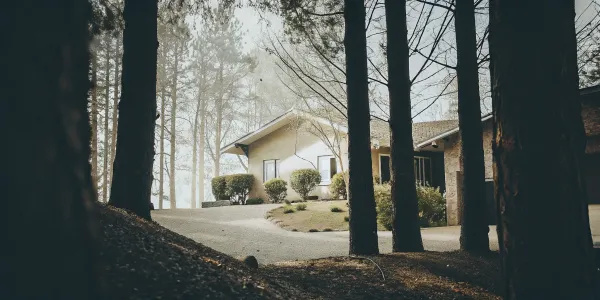
Creating Your Defensible Space, Zone by Zone
Once you understand your property’s location on the fire hazard map, it’s time to get to work. Creating defensible space is the single most important thing you can do to protect your home from wildfire. Think of it as creating a protective bubble around your house, designed to slow or stop an approaching fire by robbing it of fuel. This isn't about clear-cutting your entire property; it's a strategic approach to landscape management.
The concept is broken down into three distinct zones, starting from your home’s exterior walls and moving outward up to 100 feet. Each zone has specific goals and maintenance requirements based on guidelines from fire safety experts like CAL FIRE. Following these steps helps keep firefighters safe when they need to defend your home and can make a real difference in its survival. Let’s walk through what you need to do in each zone to build a safer, more resilient property.
Managing Zone 0: Your Ember-Resistant Zone (0-5 ft.)
This is the most critical area, the five feet immediately surrounding your home's foundation. The main threat here isn't direct flame, but wind-blown embers that can collect and ignite flammable materials. Your goal is to make this zone completely non-combustible. Start by removing any wood mulch, bark, or flammable ground cover and replace it with hardscaping like gravel, pavers, or concrete.
Routinely clear away all dead leaves, pine needles, and other debris from your roof, gutters, and the areas under your deck, porch, and stairs. This is also the place to move firewood piles and outdoor furniture further away from the house. Finally, make sure no tree branches hang within 10 feet of your chimney outlet.
Managing Zone 1: The Lean, Clean, and Green Zone (5-30 ft.)
In this zone, you’ll create a buffer to slow a fire’s spread. The key is to interrupt the path of the fire by removing dead vegetation and creating space between plants. Clear out all dead plants, dry grass, and weeds. You’ll want to trim trees so their lowest branches are 6 to 15 feet from the ground, and ensure their canopies are at least 10 feet away from other trees.
This spacing applies to shrubs and other flammable items, too. Keep plants well-irrigated and healthy, as green vegetation is less likely to burn. This zone should look well-maintained and park-like, with plenty of separation between potential fuel sources.
Storing Firewood and Propane Tanks Safely
Firewood stacks and propane tanks are concentrated fuel sources, so where you store them matters—a lot. According to fire safety guidelines, these items should be kept at least 30 feet away from your home and any other structures. This placement moves them well into Zone 2, significantly reducing the risk that wind-blown embers could land on them and ignite a fire right next to your house. It’s also a good practice to maintain a 10-foot clear area around your firewood pile or propane tank, free of any flammable vegetation. This simple step ensures that these necessary items don't become a major liability during a wildfire.
Managing Zone 2: The Reduced Fuel Zone (30-100 ft.)
This outer zone is your property’s first line of defense, and maintaining it is often required by law. The goal here is to continue reducing fuel for an approaching wildfire. Cut or mow any annual grass down to a maximum height of four inches. Create horizontal and vertical space between shrubs and trees to prevent fire from climbing from the ground into the tree canopies.
If you have wood piles in this zone, you must maintain at least 10 feet of bare dirt around them in every direction. By thinning out the vegetation in Zone 2, you reduce the fire’s intensity and speed, giving firefighters a much better chance to protect your home.
Horizontal Spacing for Trees and Shrubs
Creating space between plants is crucial because it interrupts a fire's path, preventing it from easily jumping from one tree or shrub to the next. The amount of space you need depends on the slope of your property, since fire spreads much faster uphill. For trees, CAL FIRE recommends a minimum of 10 feet between canopies on flat ground, increasing to 20 feet on a moderate slope, and 30 feet on a steep slope. For shrubs, the rule is based on their height. On a flat or mild slope, the space between shrubs should be at least two times their height. This increases to four times their height on a moderate slope and six times on a steep one.
Vertical Spacing to Prevent Ladder Fuels
You also need to think about the space between the ground and the tree canopy. "Ladder fuels" are low-hanging branches and shrubs that allow a ground fire to climb into the treetops, where it can become much more intense and difficult to control. To eliminate these ladders, start by removing all tree branches within six feet of the ground. Next, look at the shrubs growing underneath your trees. You need to create a gap between the top of the shrub and the lowest tree branch that is at least three times the height of the shrub. For example, if you have a four-foot-tall shrub, you need 12 feet of clear space above it before the first tree branch begins.
Your Year-Round Maintenance Checklist
Creating defensible space isn’t a one-time task—it’s an ongoing commitment to your home’s safety. Vegetation grows back, and leaves will fall again, so you’ll need a regular maintenance plan. Proper spacing between grass, shrubs, and trees is essential for slowing a wildfire, so make trimming and clearing a seasonal habit.
It’s also a good idea to check your local ordinances. Many communities have their own defensible space or weed abatement rules that may be even stricter than state requirements. Staying on top of your maintenance not only protects your property but also contributes to the safety of your entire neighborhood.
Your Defensible Space Action Plan
Now that you understand your property’s fire hazard severity zones, it’s time to create a clear, manageable plan. Think of this as your home’s personal fitness routine—a series of steps you can take to make it stronger and more resilient against wildfire. Creating defensible space is the single most important thing you can do to protect your property, and it’s completely within your control.
This isn’t about turning your yard into a barren landscape. It’s about smart, strategic landscaping and maintenance that creates a buffer between a potential wildfire and your front door. By following the guidelines for each zone, you’re not just checking a box for compliance; you’re actively reducing the fuel a fire needs to spread. This work is your first line of defense and can make all the difference for firefighters trying to save your home. Let’s break down exactly what you need to do.
Key Safety Measures You Can't Ignore
First things first: let’s cover the essentials. In many parts of California, especially in State Responsibility Areas (SRA), maintaining defensible space isn’t just a good idea—it’s the law. Agencies like CAL FIRE conduct inspections to ensure properties meet safety standards, because one unprepared home can put an entire neighborhood at risk. These defensible space requirements are designed to slow a fire’s spread and give firefighters a safe area to work.
Meeting these standards is the baseline for protecting your home. It involves clearing dead vegetation, properly spacing trees and shrubs, and ensuring your property is free of flammable debris. Think of these as the non-negotiable steps that create a foundation of safety for everything else you do.
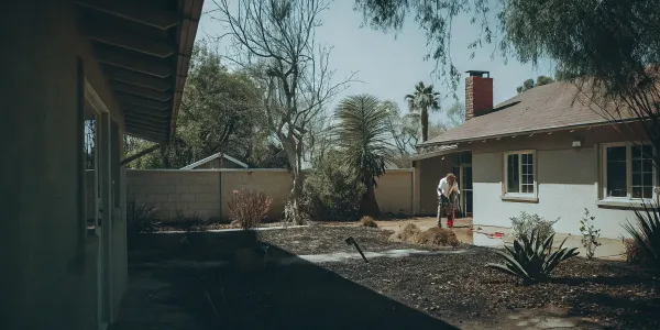
Safe Practices for Clearing Vegetation
When you’re ready to start clearing, putting safety first is essential. Try to schedule your work for a cool, calm day to minimize the risk of sparks from your equipment. Speaking of equipment, it's critical to use your tools responsibly. Before you start, double-check that any power tools, like chainsaws or mowers, have a functioning spark arrestor to prevent an accidental fire. Once you've cut everything back, have a plan for disposal. Chipping the debris for mulch or hauling it to a green waste facility are great options. Just be sure to avoid leaving large piles of dead vegetation on your property, as they can become a new fire hazard. And don't forget to protect yourself with gloves, eye protection, and sturdy clothing.
A Smarter Way to Manage Vegetation
Effective vegetation management is all about interrupting a fire’s path. Wildfires look for continuous fuel to keep moving, so your job is to create breaks. Start by removing all dead or dying plants, weeds, and dry leaves from your yard, especially within 30 feet of your home. This simple cleanup removes easy fuel for embers to ignite.
Next, focus on spacing. You want to prevent a "fuel ladder," where a fire can climb from grass to shrubs and up into trees. Trim tree branches so they’re at least six feet from the ground and ensure there’s plenty of space between individual trees and shrubs. While not always legally required yet, paying close attention to Zone 0 (the first five feet from your home) is critical for preventing embers from igniting your house directly.
Simple Steps to Protect Your Home's Structure
Your home itself can be a source of fuel. Take a walk around your house and look for anything flammable within the first 30 feet. Firewood stacks, patio furniture with combustible cushions, and propane tanks should all be moved away from the structure. Regularly clean your roof and gutters to remove any buildup of leaves, pine needles, or other debris where embers could land and smolder.
Beneath decks and patios is another critical area. Embers can easily get trapped there, so enclose these spaces with a fire-resistant screen or regularly clear out any flammable materials that accumulate underneath. These small adjustments around your home’s immediate perimeter make it a much harder target for wildfire.
Strengthen Your Roof and Vents
Your roof is your home's largest surface and its first line of defense against falling embers. If you're considering a replacement, make sure you choose materials with the highest fire rating (Class A). Just as important are the vents in your attic, eaves, and foundation. These openings are like welcome mats for embers, giving them a direct path into your home. You can harden your home by covering all vent openings with 1/8-inch metal mesh. This simple fix allows your house to breathe but keeps dangerous embers from getting inside where they can ignite flammable materials.
Secure Windows, Siding, and Fences
The intense heat from a wildfire can cause single-pane windows to shatter, creating an easy entry point for embers. Upgrading to dual-pane, tempered glass windows offers significantly more resistance and protection. Around your home’s foundation, maintain at least six inches of clearance between the ground and the bottom of your siding to prevent flames from easily climbing your walls. Finally, take a hard look at your fence. If a wooden fence connects directly to your house, it can act like a wick, carrying fire right to your structure. Replace the first five feet of any flammable fencing with a metal gate or non-combustible materials.
Install a Chimney Spark Arrestor
If you have a fireplace, your chimney can be an escape route for hot sparks and embers that could ignite your roof or nearby vegetation. A spark arrestor is a simple metal screen that fits over the top of your chimney flue, trapping those embers before they can cause a problem. It’s a small, inexpensive addition that provides a critical layer of protection, especially on windy days. Make sure yours is properly installed and regularly cleaned of any buildup to keep it working effectively and safely.
How to Document Your Work for Compliance
After you’ve put in the hard work, you need to prove it. Documenting your defensible space efforts is essential for both official inspections and insurance purposes. Take clear "before" and "after" photos of your property from various angles. Keep a simple log of the dates you completed specific tasks, like tree trimming or debris removal, and save receipts if you hire professional help.
This documentation creates a clear record of your mitigation efforts. It can be incredibly helpful when speaking with your insurance provider about your policy or during a property assessment. Some agencies also offer no-cost educational assessments to help you prepare, giving you a chance to get expert feedback and show you’re taking proactive steps.
Helpful Tools for Mapping and Monitoring
Beyond just knowing the rules, having the right tools can make managing your defensible space much more straightforward. Technology gives you access to powerful resources that can help you understand your property’s specific risks, monitor active threats, and create a clear plan of action. From official state maps that define your legal requirements to real-time wildfire trackers and self-assessment guides, these tools are designed to put you in control. They help you move from feeling overwhelmed to feeling prepared, with a clear understanding of what needs to be done and why it matters.
Mapping Your Defensible Space Zones
The first step in any solid plan is to know your starting point. The CAL FIRE Defensible Space Map is an essential tool that shows which areas in California are most susceptible to fire, helping you see where your property fits into the bigger picture. When you look at the map, you’ll see areas labeled with different Fire Hazard Severity Zones (FHSZ). These zones—rated as moderate, high, or very high—show the likelihood of a wildfire occurring and how intense it could be. This isn't just about lines on a map; it's about giving you the information you need to create a defensible space plan that is tailored to your specific risk level.
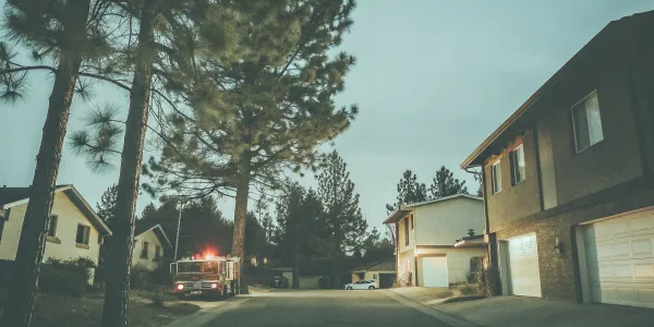
Tracking Active Wildfires
Wildfire risk isn't just theoretical; it can become an immediate threat. Knowing how to monitor active fires is a critical part of staying safe. Google Maps is a surprisingly powerful tool for this. You can turn on the "Wildfires layer" to see active fire perimeters and receive updates and safety information about the event. According to Google Maps Help, these alerts can provide crucial details during an emergency. You can also search for "wildfires near me" to see any active incidents in your area. Having this information at your fingertips allows you to stay aware of changing conditions and make timely decisions for your family’s safety.
Using Self-Assessment Checklists
Once you know your risk zone, a self-assessment can help you create a personalized action plan. Many local fire councils, like the Grand County Wildfire Council, offer checklists to help homeowners evaluate their property's readiness. These guides walk you through your defensible space zones and home structure, pointing out areas for improvement. While these checklists are a fantastic starting point, a digital tool like Defensible Space Score can give you a more detailed analysis. It analyzes your property and provides a clear, actionable report that not only improves your safety but also helps demonstrate your proactive efforts to insurance providers.
Partner with Your Local Fire Experts
Creating defensible space isn't something you have to do alone. Your local fire department and state agencies like CAL FIRE are incredible resources, not just enforcers. Think of them as your partners in safety. They have the same goal you do: to protect your home and community from wildfire. Building a good relationship with them can give you clarity and confidence as you work to make your property more resilient. They bring years of on-the-ground experience and can provide expert guidance tailored to your specific location, vegetation, and topography. This helps you focus your efforts where they matter most, ensuring your work is both effective and compliant with local codes. Instead of guessing what needs to be done, you can get clear, actionable advice directly from the people who know your area's fire behavior best. This partnership approach turns a potentially stressful task into a collaborative effort to build a safer community for everyone. It also demonstrates to insurance providers that you are taking proactive, expert-guided steps to mitigate your risk.
What to Expect During an Inspection
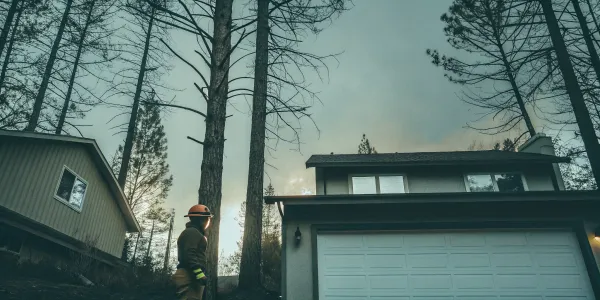
If you live in a high-risk area, you may be subject to official inspections. CAL FIRE and its partners conduct defensible space inspections in areas where the state has primary responsibility for wildfire protection, known as State Responsibility Areas (SRA). During an inspection, an official will walk your property to see if it meets state and local fire codes. They’ll check the clearance around your home and look for potential hazards. Remember, this isn't about getting a "gotcha" violation; it's about ensuring your property has a fighting chance. As CAL FIRE says, "Defensible space is the first line of defense for your home against wildfire."
How to Work with Local Authorities
While state guidelines provide a great baseline, your local city or county might have its own specific rules. It’s important to check local ordinances because they can be stricter than the state’s requirements for how to create defensible space. For example, some communities in San Diego County require 50 feet of clearance in Zone 1, which is more than the standard 30 feet. The best way to work with local authorities is to be proactive. Call your local fire department’s non-emergency line or visit their website to understand the specific requirements for your neighborhood. This ensures your hard work meets every standard and keeps your property compliant.
Understanding Local Permits and Requirements
While the CAL FIRE map gives you a solid foundation, it’s best to think of it as the minimum requirement. Your local fire department often has its own, stricter ordinances tailored to the unique conditions of your community. This is why it’s so important to treat the state map as your starting point, not the final word. In many parts of California, especially in State Responsibility Areas (SRA), maintaining defensible space isn’t just a good idea—it’s the law. Before you consider your project complete, always check with your local fire department. They will have the most accurate and up-to-date information for your address, ensuring all your hard work meets the necessary standards for both safety and compliance.
When to Call in a Professional
You don’t have to wait for an official inspection to get expert advice. Many communities participate in statewide programs that offer no-cost educational assessments to help homeowners prepare for wildfire. These programs train local agencies to provide guidance on defensible space and home hardening measures. Inviting an expert for an assessment is a fantastic way to get a personalized action plan for your property. They can point out specific vulnerabilities you might have missed and offer practical solutions, helping you invest your time and money wisely before fire season begins.
Where to Find More Help
If you want to dig deeper into the data behind these requirements, the Office of the State Fire Marshal (OSFM) is an excellent resource. Their website provides detailed information and tools for community wildfire preparedness. You can find official maps and explanations of fire hazard severity zones, which can help you understand the specific level of risk in your area. This information empowers you to make more informed decisions about protecting your home and family, turning complex regulations into a clear, manageable plan.
Related Articles
- Fire Safety Guidelines: Defensible Space Score
- Defensible Space Score FAQ
- Defensible Space Score Home
- Defensible Space Public Assessments
- Defensible Space Score Disclaimer
Frequently Asked Questions
Does being in a "Very High" Fire Hazard Zone mean I won't be able to get homeowners insurance? Not necessarily. While insurers use their own risk models, the CAL FIRE map is not the direct cause of non-renewal or rate increases. What matters most to insurance companies are the proactive steps you take. By creating and documenting effective defensible space, you demonstrate that you are actively reducing your property's risk. This can significantly improve your chances of getting and keeping affordable coverage, even if you live in a high-risk zone.
Do I have to cut down all the trees within 100 feet of my house? Absolutely not. The goal of defensible space is not to create a barren landscape but to manage vegetation smartly. It’s about creating separation to prevent fire from spreading. This means removing dead trees and plants, trimming the lower branches of mature trees to keep flames on the ground, and ensuring there is adequate space between tree canopies. A well-maintained, park-like setting is much safer than a dense, overgrown one.
Is creating defensible space a one-time project? Think of it more like regular home maintenance. Just as you clean your gutters or check your smoke detectors, you need to tend to your defensible space. Vegetation grows back and dead leaves accumulate, so it's important to have an ongoing plan. A good habit is to do a major cleanup before the start of fire season and then walk your property periodically to clear away any new debris, especially after windy days.
My property is on a steep hill. Do the defensible space zones work the same way? Topography plays a big role in how fire behaves. Fire spreads much faster uphill, so if your home is on a slope, you may need to extend your defensible space zones, particularly on the downhill side. The standard 100-foot guideline is a minimum, and steeper terrain often requires more aggressive clearing. This is a perfect situation to consult your local fire department for specific advice tailored to your property.
The state map says one thing, but my local fire department has different rules. Which one should I follow? Always follow your local rules. The CAL FIRE map provides the baseline standard for the state, but your local fire district has the authority to enforce stricter requirements based on unique community conditions. They have the most current and specific information for your neighborhood, so treat their guidelines as the final word for compliance and safety.