How to Find & Understand Your Wildfire Risk Score
Find your free wildfire risk score by address and learn practical steps to protect your home, lower your risk, and improve your chances for insurance.
If you live in a wildfire-prone area, you know the dread that comes with a letter from your insurance company. Premiums are climbing and non-renewals are becoming more common, leaving many homeowners feeling powerless. Insurers use a complex wildfire risk score to make these decisions, often with data you never get to see. But what if you could access that same insight? Understanding your home's specific vulnerabilities is the first step to taking back control. Getting a free wildfire risk score by address lets you see your property through an insurer's eyes, giving you an actionable plan to lower your risk and improve your insurability. This guide will show you exactly how.
Key Takeaways
- Treat Your Score as a Roadmap: Your wildfire risk score is a powerful tool that identifies specific threats to your property, including the often-overlooked danger from wind-blown embers. Use it to create a clear, targeted action plan for protecting your home.
- Prioritize Defensible Space and Home Hardening: The most effective way to lower your risk is by managing the area around your home and reinforcing the structure itself. Simple, high-impact projects like clearing the first five feet around your foundation and covering vents with metal mesh make a significant difference.
- Use Free Tools and Local Resources: Begin with free online tools to assess your property, then connect with local experts like your fire department or a Fire Safe Council. These groups offer tailored advice, support, and information on financial aid to help you complete your projects.
What Is a Wildfire Risk Score?
Think of a wildfire risk score as a simple rating for your property's safety, usually on a scale from 1 (minimal risk) to 10 (extreme risk). This score estimates your home's chances of being affected by a wildfire over the next 30 years. It’s not just about whether flames could reach your doorstep; it also accounts for the danger from embers, which can travel long distances on the wind and are a primary cause of home ignition. This number gives you a clear, at-a-glance understanding of your home's vulnerability.
Knowing your score is the first step toward taking control. It helps you pinpoint specific threats and create a solid plan to protect your property. While different tools might use slightly different scales or names, the goal is always the same: to provide a data-driven assessment of your home's unique situation. By understanding your score, you can make informed decisions about everything from landscaping and home maintenance to your insurance coverage.
The Scale of Wildfire Risk in the U.S.
While the idea of a risk score is straightforward, the numbers themselves can vary. Different organizations use different scales to measure wildfire risk, so you might see a few different ratings for your property. For example, some systems use a simple 1 to 10 scale, where 1 is minimal risk and 10 is extreme. Others, like Verisk’s FireLine score used by many insurers, range from 0 to 30. The federal government also has its own system; the FEMA National Risk Index provides a comprehensive look at community-level risk across the country. Try not to get bogged down by the specific number. What’s most important is understanding where your property falls on the spectrum—low, moderate, or high—so you can focus on the right improvements to protect your home.
What Goes Into Your Wildfire Risk Score?
Your wildfire risk score isn’t a random number; it’s calculated using several key pieces of information about your property and its surroundings. The most significant factors include the type of vegetation around your home—are you surrounded by dense, dry forests or sparse, well-maintained greenery? Your proximity to wildland areas also plays a huge role. Other critical inputs are historical fire data for your region and typical weather patterns, like strong winds or frequent droughts. Together, these elements create a comprehensive picture of what influences your home’s specific risk level and how that might change over time.
How Is a Wildfire Risk Score Calculated?
The calculation behind your score is a sophisticated process that models how a wildfire might behave in your specific area. It looks at both your current risk and how that risk could change in the future due to climate factors. The models consider how things like vegetation, weather, and the slope of your land could contribute to a fire's spread. A score of 1 typically means there is no modeled exposure to wildfire. The assessment evaluates the likelihood of direct impact from flames as well as the more common threat of exposure to wind-blown embers, giving you a complete view of your property’s vulnerability.
Common Scoring Models Used by Insurers
Insurance companies rely on specific, data-driven models to determine a property's wildfire risk. While you might not see these scores on your policy statement, they play a huge role in determining your premiums and eligibility for coverage. Think of them as the industry standard for risk assessment. Understanding the factors these models prioritize can give you a clearer picture of how an insurer views your home. Two of the most common scores you’ll encounter are FireLine from Verisk and the Wildfire Risk Score from CoreLogic.
FireLine by Verisk
FireLine is one of the most widely used scores in the insurance industry, rating properties on a scale from 0 (lowest risk) to 30 (highest risk). This model focuses on three core elements that influence how a fire might behave near your home. It analyzes the amount of nearby vegetation that could act as fuel, the steepness of the land, and how easily emergency vehicles can reach your property. Many insurers use this score to get a quick, standardized snapshot of a home's vulnerability based on these critical environmental factors.
CoreLogic Wildfire Risk Score
Another key player is the CoreLogic Wildfire Risk Score, which rates risk on a scale of 1 to 100. This model takes a slightly broader approach by considering not only vegetation and terrain but also historical wildfire patterns in your area. Crucially, it also calculates the risk from wind-blown embers, which are responsible for igniting a majority of homes lost in wildfires. By factoring in how far embers could travel and where they might land, this score provides a comprehensive look at both direct flame and indirect ember threats to your property.
How Your Score Impacts Insurance and Home Value
Your wildfire risk score can have a direct impact on your wallet. Insurance companies use these scores to help determine how likely it is that a property will be damaged in a wildfire. A higher score often leads to higher premiums, and in some areas, it can make it difficult to find coverage at all. This number is also becoming a critical factor in the real estate market, as more buyers are checking risk scores before making an offer. Understanding your score helps you anticipate these challenges and take steps to lower your risk, which can make your home more insurable and appealing to future buyers.
Why Insurers Use Wildfire Risk Scores
Insurance companies are in the business of managing risk, and wildfire scores are one of their most important tools for doing that. They use these numbers to get a quick, data-backed snapshot of how likely your property is to be affected by a wildfire. This single score helps them decide if they will sell you insurance, whether to renew your existing policy, and how much you’ll pay in premiums. It’s not personal; it’s a standardized way for them to assess their own financial exposure across thousands of properties. By understanding the factors that go into your score, you can start to see your home from their perspective and identify the changes that will have the biggest impact on your insurability.
Common Insurance Consequences of a High Score
A high wildfire risk score can create some serious hurdles when it comes to insurance. Many homeowners are discovering that a high score makes it difficult to get a new policy or even keep the one they have. Insurance providers have different tolerance levels; some might not insure a home with a risk score as low as 2 on certain scales, while others might be more flexible. This inconsistency can be frustrating, but the trend is clear: as risk scores go up, coverage options shrink. If your score is too high, you may receive a non-renewal notice, forcing you to find a new provider in a market that is already challenging for homeowners in high-risk areas.
The Financial Impact on Homeowners
Beyond just finding coverage, a high wildfire risk score directly affects your finances. Insurers price their policies based on risk, so a higher score almost always translates to a higher premium. For some, this means a modest increase, but for others, the jump can be dramatic. It’s not uncommon for homeowners to see their insurance costs double or even triple after being non-renewed and forced into a higher-cost plan. In the most extreme cases, homeowners may have to turn to last-resort options like a state FAIR Plan, which often provides less coverage for a significantly higher price. Taking proactive steps to lower your score isn't just about safety—it's a critical strategy for keeping your home affordable.
Wildfire Risk Score Myths, Busted
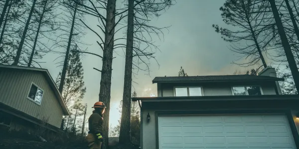
One of the most dangerous myths is thinking, "I don't live right next to a forest, so I'm safe." The reality is that most homes destroyed by wildfires are not ignited by the main fire front but by embers carried by the wind. These small, glowing embers can travel a mile or more, landing on roofs, in gutters, or on flammable materials near your home. This is why creating defensible space is so critical, no matter how far you are from dense woodland. Your risk score accounts for this ember threat, providing a more accurate picture of your true vulnerability and highlighting the importance of managing the area immediately surrounding your home.
Find Your Wildfire Risk Score with These Free Tools
Knowing your wildfire risk is the first step toward protecting your home, but it can feel overwhelming to figure out where to even start. The good news is you don’t need to hire an expert right away. There are several fantastic, free online tools that can give you a clear, data-backed picture of your property’s specific situation. These resources analyze everything from the vegetation around your home to broader community-level threats. Using them helps you move past the anxiety of the unknown and gives you a solid foundation for creating an effective action plan.
Defensible Space Score Platform
The Defensible Space Score is an excellent starting point because it focuses on what you can immediately control: the area right around your house. This tool provides a clear, data-driven assessment of your defensible space—that critical buffer between your home and the surrounding wildland. Instead of just a vague risk rating, you get a comprehensive analysis that translates into specific, actionable recommendations. For example, it might suggest clearing pine needles from your roof or trimming trees that overhang your deck. This is incredibly valuable for guiding your weekend projects and, just as importantly, for demonstrating your proactive safety measures to insurance providers, which can significantly improve your home’s insurability.
Risk Factor by First Street Foundation
If you’re looking for a "big picture" view of your specific address, Risk Factor from the First Street Foundation is a must-use tool. You simply type in your address to get a detailed report on your property's wildfire probability over the next 30 years. This long-term forecast is invaluable for understanding how climate change might affect your home's future risk. The platform is incredibly user-friendly and helps you visualize potential danger by breaking down the complex factors contributing to your score. It’s a powerful way to understand your risk compared to your neighborhood, county, and even the entire country.
Wildfire Risk to Communities
Wildfire doesn't stop at property lines, which is why the Wildfire Risk to Communities website is so useful. While it's designed to help community leaders, it offers powerful insights for individual homeowners, too. The site features interactive maps and data that let you explore your neighborhood’s overall vulnerability. You can see how shared factors like local topography and widespread vegetation types contribute to your collective risk. Understanding this broader context helps you see how a fire might behave as it approaches your area and can be a great starting point for conversations with neighbors about creating a more fire-resilient community together.
USDA Forest Service Maps and Data
For those who appreciate robust, science-backed data, the resources from the USDA Forest Service are top-notch. This initiative, which supports the Wildfire Risk to Communities tool, was created to give the public better access to high-quality risk information. The website provides a wealth of information through interactive maps, charts, and downloadable reports. You can explore risk assessments for the entire country, then zoom in to see how national trends apply to your backyard. It’s a great resource for understanding the large-scale environmental factors that influence your local wildfire risk, giving you a high-level view that complements the property-specific details from other tools.
Find Your State's Assessment Tools
Finally, don’t overlook the resources offered by your own state or local fire agency. These tools are often tailored to the unique fire ecology and building regulations in your area, providing a more customized assessment. For instance, as insurance costs rise in states like Colorado, a state-level wildfire risk report can offer critical, localized insights. These platforms might include information on local grant programs for home hardening or specific guidance on native, fire-resistant plants. A quick online search for ‘[Your State] wildfire risk map’ or checking your state’s forestry or fire department website is often the best way to find these valuable, targeted resources.
Understanding the Differences in Public-Facing Tools
When you start looking into wildfire risk, you'll find a few different kinds of tools, and it’s helpful to know they don’t all do the same thing. Some are designed to give you a microscope view of your own yard, focusing on the things you can change this weekend. Others offer a telescope view, showing you how your entire community fits into the larger landscape of risk. Knowing the difference helps you pick the right tool for the job, whether you're planning your next home maintenance project or preparing for a community safety meeting. This allows you to build a complete picture of your situation, from your fenceline to the entire region.
Individual vs. Community-Level Assessments
Individual assessment tools are all about what you can personally control. A platform like the Defensible Space Score, for example, zeroes in on the area immediately surrounding your home. It provides a clear, data-driven analysis of your defensible space and translates that into specific, actionable recommendations—like clearing pine needles from your roof or trimming trees that overhang your deck. This is incredibly useful for guiding your weekend projects and for showing proactive safety measures to insurance providers, which can significantly improve your home’s insurability and give you peace of mind.
Community-level tools, on the other hand, give you a sense of the collective vulnerability in your area. The Wildfire Risk to Communities site features interactive maps that let you explore your neighborhood’s overall risk profile, considering shared factors like local topography and vegetation types. Understanding this bigger picture helps you see how a fire might behave as it approaches your area. It’s also a great way to start conversations with neighbors about working together to create a more fire-resilient community, because safety doesn't stop at your property line.
For a long-term forecast, the Risk Factor tool offers a 30-year projection of your property's wildfire probability, which is invaluable for understanding how climate change might affect your future risk. It’s also smart to check for state-specific resources. Local fire agencies often provide assessments tailored to your area’s unique fire ecology and building codes, and they may have information on local grant programs for home hardening projects. These resources can offer critical, localized insights that complement the broader online tools.
How to Interpret Your Wildfire Risk Score
Getting your wildfire risk score can feel a little like looking at a report card. But instead of a grade, it’s a number that gives you a clear, data-driven snapshot of your property's vulnerability to wildfire. Think of it less as a final judgment and more as a starting point—a powerful tool that shows you exactly where your risks are and what you can do about them. Understanding the components of your score is the first step toward creating a solid action plan to protect your home, your family, and your investment. It transforms a vague sense of worry into a focused set of tasks you can actually tackle.
From Low to Extreme: Understanding Score Ranges
Most wildfire risk assessments use a simple scale, often from 1 to 10. A score of 1 indicates minimal risk, while a 10 signals extreme risk. This number isn't just pulled out of thin air; it represents the comprehensive likelihood of your property being affected by a wildfire over the next 30 years. This includes the danger from direct flames as well as the more common threat of wind-blown embers from a nearby fire. A platform like First Street Foundation calculates a Fire Factor® for every property, giving you a clear indicator of your long-term exposure. Seeing a high number might be unsettling, but it gives you the essential information you need to start making meaningful safety improvements.
A Closer Look at Your Key Risk Factors
Your score is a blend of several critical factors related to your home and its surroundings. Assessors look at the big picture, not just your house itself. Key elements include the slope of your land (fire moves faster uphill), the types of vegetation and fuel sources nearby, and your home's construction materials. They also heavily weigh your defensible space—the buffer zone you create between your home and the surrounding landscape. Other considerations, like road access for emergency vehicles and the availability of local fire suppression resources, also play a role. While you can't change the slope of your property, you have significant control over your defensible space and home hardening, which can dramatically influence your score.
How Does Your Score Compare to Your Neighbors?
A risk score is most useful when you understand how it fits into the broader picture of your neighborhood and community. A score of 6 might be average for your town but would be considered high in a different region. Tools like the Wildfire Risk to Communities website are designed to help you explore this local context. By seeing how your property’s risk compares to others nearby, you can better understand shared vulnerabilities and opportunities for community-wide action. Wildfire doesn't stop at property lines, so working with neighbors on fuel reduction and emergency planning can create a much safer environment for everyone.
Will Your Score Affect Your Insurance Policy?
Your wildfire risk score has a direct and significant impact on your homeowners insurance. Insurance companies use these scores to calculate your premiums, and a higher score almost always means a higher price. In many high-risk areas, a poor score can even lead to non-renewal of your policy, leaving you scrambling for coverage. According to insurance experts, these wildfire risk scores are a primary tool for carriers to manage their own financial exposure. The good news is that by taking documented steps to lower your risk, you can often improve your score and, in turn, improve your standing with your insurance provider, making it easier to secure and maintain affordable coverage.
Your Wildfire Risk Score and Your Home's Value
Beyond insurance, your wildfire risk score can also affect your property's market value. A home with a high risk score and poor defensible space can be a red flag for potential buyers, who may be concerned about safety, future insurance costs, and the overall investment. In some regions, widespread wildfire risk can impact the entire real estate market, as the cost of insurance rises for everyone. On the flip side, a low score—or a high score with a clear, documented mitigation plan—can be a powerful selling point. It shows that the property is well-maintained, insurable, and resilient, making it a more attractive and secure investment for the next owner.
Limitations and Oversight of Wildfire Risk Scores
While wildfire risk scores are incredibly useful tools, it’s important to remember that they aren’t perfect. They are data-driven estimates, not infallible predictions of the future. Understanding their limitations helps you use them more effectively—not as a final verdict on your home's fate, but as a guide to focus your efforts. Some models can overlook key factors, and the industry as a whole lacks a standardized system for oversight. This doesn't mean the scores are useless; it just means your personal knowledge of your property and your proactive mitigation efforts are an essential part of the equation for creating a truly fire-resilient home.
What Current Models Might Miss
Many of the scoring models used by insurance companies are excellent at analyzing the risk posed by vegetation and wildlands surrounding a property. However, they can sometimes fall short in assessing the danger of house-to-house fire spread, a major factor in suburban wildfires. For example, some analyses of the 2017 Tubbs Fire that devastated Santa Rosa's Coffey Park neighborhood suggest that the fire spread rapidly from one home to the next, even though the area wasn't considered a high risk based on vegetation alone. This is why your own home hardening efforts are so critical. A model might not see the risk from a neighbor's woodpile, but you can, and you can take steps to protect your own home from that vulnerability.
The Lack of Regulation and Oversight
It might surprise you to learn that there are currently no specific laws or regulations governing the accuracy or fairness of the wildfire risk models used by insurers. Because these are proprietary tools, there is no standardized system for how they are built or applied. According to the consumer advocacy group United Policyholders, there is also no formal process for a homeowner to appeal or challenge their score if they believe it’s inaccurate. This lack of oversight can feel frustrating, but it highlights the importance of being your own best advocate. By documenting your mitigation work, you create your own evidence to show that your home is a safer, more insurable risk than a simple score might suggest.
Challenging an Inaccurate Score
While there isn't a formal appeals court for wildfire risk scores, you aren't entirely without options. The best way to "challenge" an unfavorable score is to build a strong case with your insurance provider. Start by meticulously documenting every mitigation project you complete. Take before-and-after photos of your defensible space work, keep receipts for professional tree trimming or vent replacements, and get a formal assessment from your local fire department if they offer one. A detailed report from a platform like Defensible Space Score can also serve as powerful, third-party validation of your efforts. Present this portfolio to your insurance agent to demonstrate that you have actively reduced your property's risk, which may help them see your home in a more favorable light.
How Government Agencies Assess Community-Wide Risk
While your insurance company is focused on the risk to your specific property, government agencies take a much broader view. They assess wildfire risk at the community, county, and even national levels to inform public policy, direct funding for large-scale mitigation projects, and plan emergency response. These assessments aren't designed to set your insurance premiums but to help leaders understand where the greatest threats are and how to best allocate resources to protect lives and infrastructure. Understanding these community-level assessments can give you valuable context for your own preparedness efforts and help you engage in local safety initiatives.
FEMA's National Risk Index
One of the most comprehensive tools used by the government is the National Risk Index from the Federal Emergency Management Agency (FEMA). This online tool analyzes the risk for 18 different natural hazards across the United States, including earthquakes, floods, and wildfires. For each hazard, it provides a risk score for every county and census tract in the country. The goal of the index is to provide a clear, standardized baseline for comparing risk nationwide. This helps emergency managers, community planners, and government officials identify which areas are most vulnerable and prioritize mitigation efforts where they are needed most.
Key Metrics: Expected Annual Loss and Exposure
To create its ratings, the National Risk Index relies on key metrics like the Expected Annual Loss (EAL). This isn't a prediction for any single year, but rather a long-term average of the estimated cost of damage a community can expect from wildfires annually. This calculation includes potential damage to buildings and agriculture as well as harm to the population. By putting a dollar figure on risk, FEMA helps communities understand the financial consequences of inaction and make a stronger case for investing in preparedness and mitigation projects that can reduce that potential loss over time.
Turn Your Score into an Action Plan
Getting your wildfire risk score is the first step, but the real power comes from what you do next. Think of your score not as a final grade, but as a personalized roadmap. It shows you exactly where your property is vulnerable and, more importantly, how you can make it safer. Taking action doesn't have to be overwhelming. By focusing on a few key areas, you can significantly reduce your risk and gain peace of mind.
This plan is about making tangible improvements that protect your home and family. We’ll walk through four main strategies: creating a buffer zone around your home, strengthening the structure itself, making smart landscaping choices, and sticking to a simple maintenance routine. Each of these steps contributes to a stronger, more resilient property. You have the ability to change your home’s story from one of risk to one of readiness. Let’s get started.
How to Create a Defensible Space
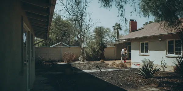
Creating "defensible space" is one of the most effective things you can do for wildfire safety. This is all about clearing plants and other flammable materials to create a buffer zone that can slow or stop a fire from reaching your home. Start with the area immediately around your house—the first five feet should be completely free of anything that can burn, like mulch, dead leaves, or flammable plants. This is your home’s last line of defense against embers.
From there, work your way out to 30 feet, focusing on thinning out vegetation and removing dead wood. The goal is to create separation between trees, shrubs, and your home. This doesn't mean you need a barren landscape, just a well-maintained one. A clear buffer gives firefighters the room they need to safely defend your property if a wildfire approaches.
Make Your Home More Fire-Resistant
While defensible space protects the area around your home, "home hardening" focuses on the structure itself. The goal is to make your house more resistant to catching fire from flying embers, which can travel a mile or more ahead of a wildfire. Using fire-resistant materials is key to enhancing your home's ability to withstand a wildfire's intense heat and flames.
Start with the most vulnerable parts: your roof and vents. A roof made of materials like composite shingles, metal, or tile is your best defense. Vents for your attic, crawlspace, and dryer are easy entry points for embers, so cover them with a fine metal mesh (1/8-inch). Other impactful upgrades include installing dual-pane windows and ensuring your siding is made from non-combustible materials.
Choose Fire-Resistant Landscaping
Your yard can either be a pathway for fire to reach your home or a barrier that helps protect it. Making smart landscaping choices is about strategically using plants and materials that reduce your fire risk. When planning your garden, it’s important to assess local land conditions, including the natural fuel types and the slope of your property, as these factors influence how fire behaves.
Choose high-moisture, low-resin plants and trees, and avoid highly flammable ones like juniper and cypress. Create space between shrubs and tree canopies to prevent fire from climbing from the ground into the treetops. Use non-flammable materials like gravel or pavers for walkways and patios, especially in the zone closest to your house. Thoughtful landscaping can create a beautiful, fire-wise property that is much easier to defend.
Your Year-Round Maintenance Checklist
A fire-safe property isn’t a one-time project; it requires consistent upkeep. Regular maintenance is crucial for reducing your home’s wildfire risk, and simple habits can make a huge difference. One of the most important tasks is keeping your roof and gutters clear of pine needles, leaves, and other debris. This buildup is basically kindling, and a stray ember is all it takes to ignite it.
Make a habit of regularly mowing dry grass and weeds, trimming tree branches that overhang your roof, and clearing dead vegetation from under your deck. Store firewood and other flammable materials at least 30 feet away from your house. Following a simple seasonal maintenance checklist ensures your property stays prepared year-round, giving you confidence that you’ve done your part to keep it safe.
Next-Level Tools for Assessing Wildfire Risk
Once you have your initial wildfire risk score, you can get an even clearer picture of your situation with more advanced tools. Think of your score as the starting point. These next-level resources use dynamic data to give you a deeper understanding of your property’s risk profile and help you stay informed when it matters most. From interactive maps that show risk across your entire neighborhood to real-time alerts sent straight to your phone, these features are designed for homeowners who want to be proactive. Using them helps you move from simply knowing your risk to actively managing it with the best information available.
How Satellite Data Informs Your Score
To see how your property fits into the bigger picture, digital mapping tools are incredibly helpful. Instead of just giving you a single score, these platforms use satellite data to create interactive maps that visualize wildfire risk across entire communities. The Wildfire Risk to Communities website is a fantastic free resource that offers maps, charts, and other tools to assess risk based on a specific address. This allows you to see how surrounding terrain and vegetation patterns contribute to your home’s vulnerability, giving you a more complete and contextual understanding of the threats you face. It’s a powerful way to see beyond your property lines.
Stay Ahead with Real-Time Monitoring
Wildfire risk isn’t static—it changes with the weather and active fire conditions. That’s why real-time monitoring is so important. Many platforms now offer live updates during emergencies. For example, you can find crisis-related alerts in Google Maps for significant events like wildfires, which provide timely safety information and evacuation notices. These systems track a fire’s perimeter, smoke direction, and road closures, giving you the critical information you need to make smart decisions for your family’s safety. Staying updated with a reliable real-time tool can make all the difference when conditions are changing quickly.
Get Wildfire Alerts on Your Phone
For on-the-go updates, nothing beats the convenience of a mobile app. Many local and regional agencies offer apps that send push notifications directly to your phone about immediate fire threats, air quality issues, and Red Flag Warnings. For example, some air quality districts have programs where you can sign up for alerts about No-Burn Days, which are essential for reducing fire risk. You can often Check Before You Burn using these local resources. Having these alerts set up means you get critical information instantly, without having to seek it out yourself.
How to Document Your Mitigation Efforts
After you’ve put in the hard work to create defensible space and harden your home, you need a way to track your progress. Documenting your mitigation efforts is not only great for your own records but can also be incredibly valuable when talking to your insurance provider. A formal Defensible Space Assessment checklist can guide you through the process, ensuring you cover all your bases, from clearing vegetation near structures to maintaining the legally required 100 feet of space around your property. Platforms like Defensible Space Score are designed to help you log these improvements, creating a clear record of the steps you’ve taken to make your home safer.
Where to Find Local Help and Resources
Getting your wildfire risk score is a fantastic first step, but you don’t have to figure out the next steps all on your own. It can feel overwhelming to look at a list of recommendations, but the good news is that you’re not alone. Protecting your home is a community effort, and there are tons of local programs and experts ready to help you turn your action plan into reality. From financial assistance for clearing vegetation to professional advice on home hardening, tapping into these resources can make the process much more manageable and effective. Think of it as building your personal wildfire safety team.
Connecting with local experts gives you access to specialized knowledge tailored to your specific environment. They understand the local topography, weather patterns, and plant life better than anyone. This local context is key to making smart, effective decisions. Your local fire department, community groups like Fire Safe Councils, and professional assessors are all valuable allies in your effort to create a safer, more resilient property. They can also help you stay on top of changing regulations and insurance requirements in your area, ensuring your hard work pays off when it matters most. Let’s look at where you can find this support.
Connect with Local Fire Prevention Programs
Many communities in high-risk areas have dedicated programs to help residents prepare for wildfires. A great place to start is the Wildfire Risk to Communities website, a free tool designed to help people understand and lower their local risk. Beyond national resources, check with your local Fire Safe Council or fire department. They often host workshops, offer free chipping services for cleared vegetation, or run neighborhood-based initiatives that make it easier to get the work done. These programs are designed with your local landscape and regulations in mind, so they provide some of the most relevant advice you can get while connecting you with neighbors who share the same goals.
Resources for Your Family's Emergency Plan
Creating defensible space and hardening your home is an important investment. The good news is you may not have to cover all the costs yourself. Many state and local governments offer financial assistance to help homeowners with wildfire mitigation efforts. You can often find information about grants and funding designed to reduce community-wide wildfire risk. Start by checking with your state’s forestry or natural resources department, as they often manage these funds. These grants can help cover expenses for things like removing hazardous trees, upgrading to fire-resistant roofing, or installing ember-proof vents, making these critical safety upgrades more accessible.
When to Call a Professional Assessor
While you can do a lot on your own, sometimes it pays to bring in a professional. A certified defensible space assessor can provide a detailed, expert evaluation of your property. They’re trained to spot hazards you might overlook, from overgrown vegetation within 10 feet of your chimney to the overall fuel load on your land. A formal defensible space assessment ensures you meet legal requirements—like the 100 feet of clearance mandated in many areas—and gives you a documented report. This report can be incredibly valuable to share with your insurance provider, offering proof of your mitigation efforts and giving you peace of mind.
How to Stay Updated on Local Regulations
Wildfire risk isn’t static. Local regulations, building codes, and insurance policies can change, so it’s important to stay in the loop. Insurance companies are paying closer attention to wildfire risk scores, and a high score can directly impact your premiums and even your ability to get coverage. Make it a habit to follow your local fire protection district or county emergency services on social media, sign up for their newsletters, and attend community meetings when you can. Staying informed helps you adapt your mitigation plan and ensures your efforts continue to meet current safety standards.
Related Articles
- How Is a Wildfire Risk Score Calculated? A Guide
- Defensible Space Score | Wildfire Risk Made Clear
- Get a Wildfire Hazard Assessment: A Complete Guide
Frequently Asked Questions
All these tools sound great, but where should I start? A great approach is to start small and then zoom out. Begin with a platform like Defensible Space Score to get a clear picture of the area you can control right now—your own yard. It will give you specific, manageable tasks. Once you have that action plan, use a tool like Risk Factor to understand how your property fits into the bigger, long-term picture of your community's risk.
My score is high. What's the single most important thing I can do to lower it? Focus on the five feet immediately surrounding your home. This is your non-combustible zone. Clearing this small but critical area of anything that can burn—like mulch, dead leaves, and flammable plants—is the most effective first step you can take. It creates a vital buffer that can stop embers from igniting your house, giving you the biggest safety return for your effort.
If I improve my property, will my insurance company automatically lower my premium? It's not usually automatic, so you'll need to be proactive. Document every single improvement you make with photos, receipts, and even a professional assessment report if you get one. Then, contact your insurance agent directly with this proof. Showing them you've actively reduced your property's risk makes you a much better client and can be a powerful tool for securing better rates or even just keeping your coverage.
How accurate are these online risk scores? Can I really trust them? Think of these scores as highly educated estimates. They are built on extensive, science-backed data, including satellite imagery, historical fire patterns, and local vegetation maps. While no tool can predict the future perfectly, they provide a very reliable assessment of your property's current vulnerability. Use your score as a guide to help you focus your energy on the most important safety improvements.
My neighbor's property is a mess. Does that affect my risk score even if my own yard is perfect? Yes, it can. Your score is heavily influenced by your own defensible space, but the models also account for the surrounding environment. An overgrown property next door increases the amount of available fuel in your immediate area, which can influence your overall risk profile. This is why community-wide efforts are so important—when neighbors work together, everyone becomes safer.